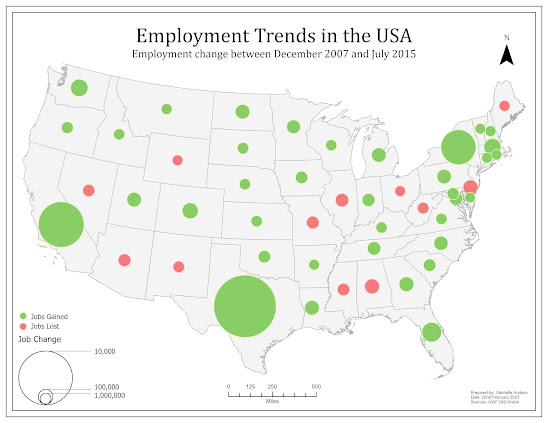
While there are many ways to display data on a map, proportional symbol and bivariate choropleth mapping can be considered two methods that are technically challenging but significantly beneficial when executed correctly. The challenges proportional symbol maps can introduce include, but is not limited to, overlapping symbols, symbols that do not have enough variation in size, and accurately displaying positive and negative values. One of the maps created for this week's lab, as seen below, is an example of a proportional symbol map that has both positive and negative values. To properly display both sets of values, the GIS professional has to create additional attribute fields that separate the positive and negative values, followed by making the negative values positive. Once this is done. The data can be symbolized and displayed effectively.

Alternatively, bivariate choropleth mapping involves showing the relationship between two data variables. This is particularly beneficial when two variables have a strong relationship or correlation. The bivariate choropleth map students were tasked with preparing this week shows the relationship between obesity and inactivity (See map below). To properly show this relationship the data from each variable should be normalized, followed by being classified via the quantile method to ensure that classes have an equal number of values. The data is then combined based on those classes and relationships can be displayed. In this instance, we can see counties that have high inactivity and high obesity, low inactivity and low obesity, high inactivity and low obesity, and low inactivity and high obesity. For this map, the creation of the classes and symbology were completed manually, however, ArcGIS Pro recently introduced functionality that creates bivariate classification and symbology.


Comments
Post a Comment